Mapping local security and safety issues; potential dangers that children encounter while going to their schools, play fields, local shopping etc.
The extent to which the built environment is friendly to the presence of people living, shopping, visiting, enjoying or spending time and especially walking in an area. A residential area shall be ideally planned in such a way that children, persons with disabilities and the elderly can move from one place to the other easily. It makes getting around easier for everyone and also avoids usage of automobiles for short trips.
Walking as a mode of transport for humans, is easy to promote, when the walkways are planned and made in such a way so as the children and the elderly can use them easily, it becomes easily usable for the whole population. Walkable areas experience reduced automobile traffic and therefore reduced congestion and air pollution. When combined with public transport, these beneficial effects can spread over large areas.
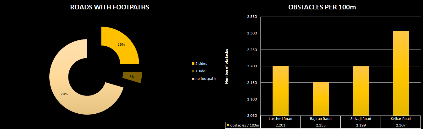
One can see that most of the streets have no footpaths or a footpath on only one side. There are a variety of hazardous obstacles placed on the footpath. These obstacles force pedestrians to go around them or off the footpath and on to the road creating a situation for accidents and potential loss of life.
OUTCOME: AROUND 70% OF THE ROADS IN THE AREA DO NOT HAVE FOOTPATHS AND ALL MAIN ROADS HAVE AN AVERAGE OF 2.2 HAZARDOUS OBSTACLES FOR EVERY 100 METERS
Walkability determines the ease of access to and moving around the neighbourhood, for various reasons like commute to and from work, to and from amenities, facilities, and services, children walking to and from school, playground etc. More walkable a neighbourhood, more likely are the people to walk and more the enviromental and social benefits.
PuneData.org © 2016